Read about famous places
key notes :
What are Famous Places?
- Famous places are well-known locations around the world.
- They can be natural wonders, historic buildings, or cultural landmarks.
Types of Famous Places
- Natural: Grand Canyon, Mount Everest, Niagara Falls.
- Historical: Taj Mahal, Great Wall of China, Pyramids of Egypt.
- Modern and Man-Made: Eiffel Tower, Statue of Liberty, Burj Khalifa.
Why Are They Famous?
- Unique design or architecture.
- Historical importance.
- Cultural or religious significance.
- Natural beauty or wonder.
Learning About Famous Places
- Helps students explore the world.
- Builds reading comprehension skills.
- Improves knowledge of geography, history, and cultures.
How to Read About Famous Places
- Look at the title and headings to guess what the text is about.
- Use maps or pictures to understand the location.
- Read slowly and carefully to learn facts and interesting details.
Vocabulary to Know
- Landmark
- Monument
- Architecture
- Tourist
- Heritage
- Historic
Learn with an example
▶️ Read the text about the Gateway Arch.
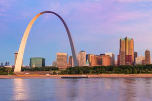
The Gateway Arch in St. Louis, Missouri, is a gleaming stainless steel structure that soars 630 feet above the Mississippi River. The Gateway Arch represents a doorway to the West. In 1804, Lewis and Clark started their exploration of the West from the city of St. Louis, and many other pioneers also passed through the city as they headed west.
Completed in 1965, the monument was designed by the famous architect Eero Saarinen. Saarinen had to get the measurements of the structure just right. He designed the Arch so that the distance between the legs is exactly the same as the distance from the ground to the highest point of the Arch: 630 feet. The Arch’s legs are triangle-shaped. At ground level, each of the triangles’ sides is 54 feet long. They gradually narrow to 17 feet at the top. As the Arch was being built, workers stacked and joined together premade sections of both legs from the ground up. In order for the two sides to join together at the top, the placement of the legs needed to be precise. If the legs had been off by even 1/64 of an inch, the two sides could not have joined together!
Other important designs were engineered into the monument as well. In order to withstand high winds and earthquakes, the Arch was designed to sway up to 18 inches from side to side. And inside the Arch’s hollow legs, there is a one-of-a-kind tram system. The tram is a little like an elevator and a little like a Ferris wheel. Eight five-passenger capsules in each leg take visitors on a four-minute ride to the top of the Arch. There, people can get out and look through sixteen small glass windows on either side. From this high viewpoint, about one million visitors each year look to the east, where the many pioneers first settled, and to the west, where the nation’s pioneers ventured forth.
Based on the text, which of the following describe the location of the Gateway Arch? Select all that apply.
- along the Missouri River
- in St. Louis, Missouri
- along the Mississippi River
- in the state of Mississippi
Look at the text in bold below. It tells you where the Gateway Arch is located.
The Gateway Arch in St. Louis, Missouri,is a gleaming stainless steel structure that soars 630 feet above the Mississippi River. The Gateway Arch represents a doorway to the West. In 1804, Lewis and Clark started their exploration of the West from the city of St. Louis, and many other pioneers also passed through the city as they headed west.
▶️ Read the text about the island of Bora Bora.
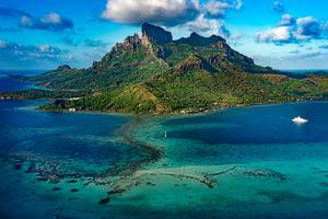
Surrounded by waters that glow a bright turquoise colour, Bora Bora is like a colourful painting. This mountainous island in the South Pacific is formed by volcanoes. The black rock of Mt Otemanu at the island’s centre stands out against the rich green hills around it. Sandy white beaches skirt the edges of the island. A string of tiny islands called motus surround the large island. The motus sit on the edge of a peaceful lagoon filled with colourful sea life.
The Polynesians first settled Bora Bora around the ninth century. Their rich history and traditions still thrive among the native people of the island. European explorers first visited in the 1700s. Over the years, people from different parts of the world have left their mark on the island. Bora Bora is now part of French Polynesia. Its location in the middle of the Pacific, halfway between Australia and South America, led to its brief use as a US military base during World War II.
Today, this peaceful place, with its natural beauty and welcoming people, is a popular holiday spot. Visitors come from around the world to relax in bungalows sitting on stilts right above the water. Those who choose to leave the comfort of their tiny thatched-roof cottages can explore the underwater world. One favourite spot for snorkelling and diving is a natural coral garden nicknamed ‘the aquarium’. People even enjoy swimming with the many stingrays, blacktip reef sharks and yellow-coloured lemon sharks found in the island’s waters. These creatures pose no threat to humans. Bora Bora is a beautifully colourful and serene world in and out of the water.
Based on the text, which statement is true of Bora Bora today?
- It is an island where people go to relax and watch sea life.
- It is an active US and French military base in the South Pacific.
- It is a volcanic island with beautiful sea life but no homes.
- It is a string of small islands left empty after World War II.
The text describes the island of Bora Bora as a colourful, peaceful place with natural beauty and welcoming people. It states that today, it’s ‘a popular holiday spot‘ where people go to relax and ‘explore the underwater world’.
So, it’s true that today Bora Bora is an island where people go to relax and watch sea life.
▶️ Read the text about Uluru, in central Australia.
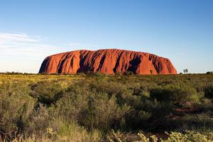
Uluru is a stunning natural landmark. This giant sandstone formation, which was also named Ayers Rock by white explorers, lies in the Northern Territory. Geologists believe Uluru is about 550 million years old. Like an island mountain, it rises more than 300 metres above the flat desert surrounding it. It is one of the most famous landmarks in Australia. It is also a place that holds great meaning for the Indigenous Anangu people who have lived there for thousands of years.
Visitors to Uluru are asked to respect its importance to the Anangu people. The Anangu believe that their ancestors were spirit people who created Uluru and all its features. According to traditional thinking, the rock shapes, caves and cliffs are remnants of their ancestors’ time on Earth, called the ‘Dreamtime’. The Anangu believe that the rocks themselves, along with the paintings and carvings on the rocks, are what have been left behind to tell the legends and lessons of their ancestors.
Because of Uluru’s importance to the Anangu people, climbing it is no longer allowed. Taking pictures of certain places that the Anangu prefer to keep hidden is also discouraged. However, people are welcome to explore. Visitors can walk the nearly ten-kilometre path around the base of the rock. Guides can point out Indigenous plants and animals, such as wild fig trees and red kangaroos. Many people come at dawn or sunset to experience the stunning way the rock turns deep orange and fiery red as the light changes.
Based on the text, what is special about Uluru?
- Its rocks are believed by geologists to be the oldest rocks in the world.
- It is an Australian landmark that means a great deal to the Anangu people.
- It is the most popular tourist spot on the continent of Australia.
- It is the tallest mountain in Australia and a popular hiking spot.
Look at the text in bold below. It tells you what is special about Uluru.
Uluru is a stunning natural landmark. This giant sandstone formation, which was also named Ayers Rock by white explorers, lies in the Northern Territory. Geologists believe Uluru is about 550 million years old. Like an island mountain, it rises more than 300 metres above the flat desert surrounding it. It is one of the most famous landmarks in Australia. It is also a place that holds great meaning for the native Anangu people who have lived there for thousands of years.
let’s practice!
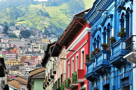
Read the text about the city of Quito, Ecuador.
The city of Quito lies high in the Andes Mountains of South America. Long ago, it was a marketplace of the native Quitu people. Later, it was conquered by the Incas and then by the Spanish, who built a colonial capital on the Incan ruins in 1534. The city still has many well-preserved churches, statues and colourful colonial houses. In 1978, Quito became the first city to be placed on the World Heritage List by UNESCO, an international group whose work includes preserving historical places.
Today, Quito is the capital city of Ecuador. It is also the closest capital city to the equator. One of the highest capital cities in the world, Quito sits over 2,800 metres above sea level. The active volcano Pichincha towers over the west side of the city. In fact, Quito is surrounded by volcanoes. A volcano called Cotopaxi erupted in 2015. For months, it spewed ash all over the city and surrounding areas. On clear days, the magnificent, snow-topped cone of this volcano can be seen looming over the city.
The best time to see Cotopaxi and the surrounding volcanoes is in Quito’s dry season, which lasts from June to September. This is when the skies are more likely to be sunny and clear. The rest of the year is the wet season. There are more clouds and rain during this time, but there is little difference in the average temperature. Because of its location in the mountains and on the equator, the average year-round temperature in Quito is about 15°C, neither hot nor cold. This moderate climate makes Quito a pleasant place to visit at any time of year.